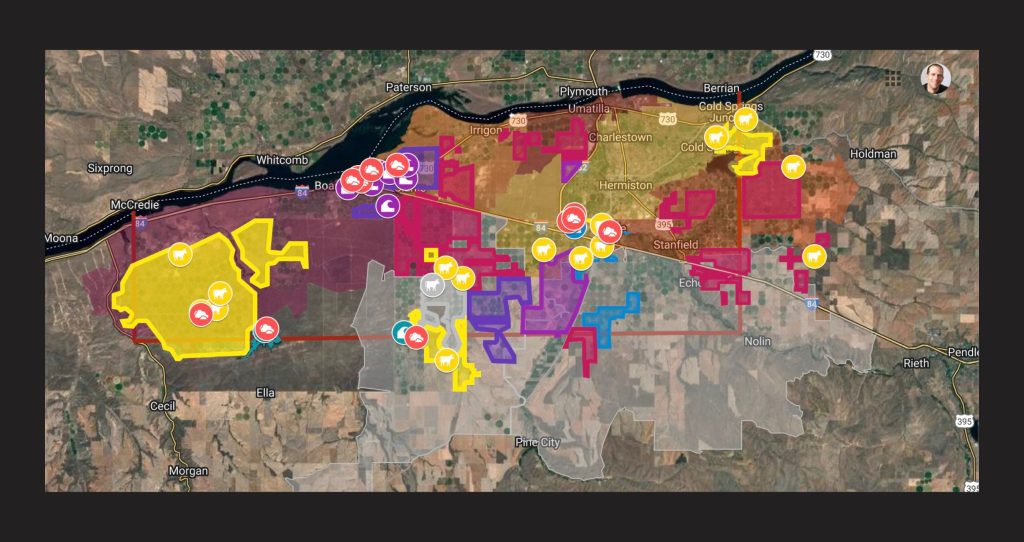
Interactive maps of Umatilla and Morrow Counties show concentration and severity of groundwater & air pollution in Oregon’s rural “sacrifice zone”
For over two decades, residents of eastern Oregon’s Morrow and Umatilla Counties have been poisoned by nitrates in their groundwater. According to the National Institutes of Health, nitrate exposure above the legal limits can lead to cancer, birth defects, thyroid problems, and other health problems including methemoglobinemia, a deadly disease that affects infants. Oregon Rural Action has been on the forefront of this fight for clean drinking water and has recently released interactive maps (English language map / Mapa del idioma español) to illustrate the extent of the contamination.
“Working class people can’t spend all day filing public records requests and pouring over permitting documents. This map puts the information in one place where anyone can see for themselves how bad it’s gotten.”
“This is one of the most polluted places in Oregon, but most people who live here don’t know how bad it is,” said Kaleb Lay, ORA’s Director of Policy & Research. “Working class people can’t spend all day filing public records requests and pouring over permitting documents. This map puts the information in one place where anyone can see for themselves how bad it’s gotten.”
Keep up to date with grassroots organizing in the West with WORC’s newsletter.
The maps clearly show that nitrates affecting communities in Lower Umatilla Basin’s groundwater come from a dozen Confined Animal Feeding Operations (CAFOs), nearly two dozen sources of industrial wastewater, and some of the largest industrial agriculture operations in the area. The maps also show how these facilities generate high levels of industrial air pollution. The map’s pollution data was compiled from federal and state agencies. These agencies have had pollution source data for decades, but have never put it in a public-friendly format.
“Regulators would never allow pollution to get this out of hand in a wealthy Willamette Valley suburb, but since these are working-class, heavily Latino communities that happen to be east of the Cascades, we get treated differently.”
The maps also include drinking water wells tested by the Oregon Health Authority. Over half of the 1,700 wells tested show unnaturally high levels of nitrates, with many of those testing well above the safe drinking water limit. Half of the area’s wells remain to be tested. The air quality layers of the map show a similarly troubling picture. Four of Oregon’s five top polluting power plants are located in the Lower Umatilla Basin, and much of the electricity they produce is exported out of northeast Oregon. In 2022, 43% Oregon’s large industrial facility air emissions were released in Morrow and Umatilla Counties, according to the EPA.
“The unchecked growth of industry and corporate agriculture has turned these communities into sacrifice zones, all for the sake of profit,” said ORA Executive Director Kristin Anderson Ostrom. “Regulators would never allow pollution to get this out of hand in a wealthy Willamette Valley suburb, but since these are working-class, heavily Latino communities that happen to be east of the Cascades, we get treated differently.”
Learn more:
Right to Farm Laws Mean There’s No Justice for People Hurt By CAFOs
Toxic Coal Ash Threatens Groundwater Around the US
Working for Accountability in the Pavillion Water Crisis

Yes, I want to help WORC elevate Western voices and hold decision-makers accountable!


